Group Eleven Intersects 14.4m of 0.22% Cu and 2.1 g/t Ag and 1.6m of 0.53% Cu and 22.3 g/t Ag at Gortdrum Prospect, PG West Project, Ireland
Vancouver, Canada, March 22, 2021 – Group Eleven Resources Corp. (TSX.V: ZNG; OTC: GRLVF; FRA: 3GE) (“Group Eleven” or the “Company”) is pleased to announce results from exploration drilling at the Gortdrum copper-silver prospect (“Gortdrum”) at its 100%-owned PG West project (“PG West”), Republic of Ireland.
Highlights:
- Two holes (totalling 380.9 metres) were drilled 1.0 km and 2.2 km, respectively, from the old Gortdrum copper mine, along the main mineralizing structure - the “Gortdrum Fault Zone”
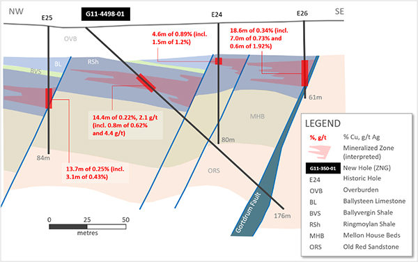
- G11-4498-01 intersected 14.4 metres of 0.221% Cu and 2.1 g/t Ag (0.240% CuEq), including 0.80 metres of 0.620% Cu and 4.4 g/t Ag (0.660% CuEq) and including 0.90 metres of 0.387% copper and 3.1 g/t silver (0.416% CuEq) at shallow depths (46.2 metres downhole; true width estimated at 60%)
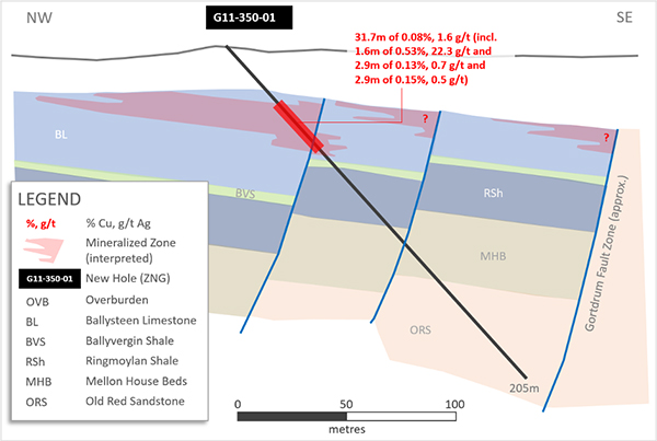
- G11-350-01 intersected a broad zone of highly anomalous copper (31.7 metres of 0.080% Cu and 1.6 g/t Ag), including 1.6 meters of 0.532% Cu and 22.3 g/t Ag (0.735% CuEq) and 2.9 metres of 0.151% Cu and 0.5 g/t Ag (0.156% CuEq) starting at shallow depths (32.4 metres downhole; true width estimated at 60%)
- Results represent the first drilling at Gortdrum since 1975 and provide evidence for, not one – but a series, of parallel faults across several hundred metres and a strike of three kilometres
“We are encouraged that Group Eleven’s first-ever drill campaign at Gortdrum has been successful in demonstrating the potential scale and tenor of this impressive copper-silver prospect,” stated Bart Jaworski, CEO. “Gortdrum was the first asset acquired by the Company and, after being effectively off-the-market for over 40 years previously, it is great to see this prospect finally get the attention it deserves. Gortdrum is integral to our flagship PG West zinc project in the Limerick Basin and is thought to represent the copper-rich ‘roots’ of the zinc prospects in the area.”
“Now that detailed data-compilation has been completed, we’ve been pleasantly surprised at just how extensive and continuous the zone of shallow copper mineralization appears to be. We see a lot of scope for a step-change at Gortdrum given most historic holes were drilled vertically (on very steep structures), very few historic intercepts were assayed for silver and prospective NW-trending splay faults do not appear to have yet been explored.”
Drill Program at Gortdrum (100%-interest PG West Project)
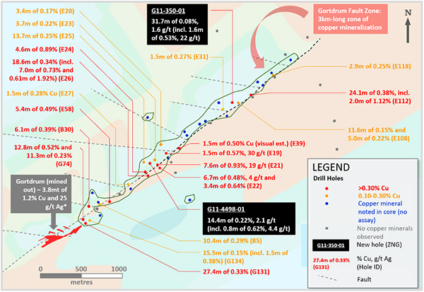
Two diamond drill holes were completed at the Gortdrum Cu-Ag prospect: G11-4498-01 (176.3 metres depth, azimuth 148°, dip -45°) and G11-350-01 (204.6 metres, azimuth of 125° and dip -45°). Key assay results are shown in Exhibit 1. The holes were located approximately 1.0 km and 2.2 km, respectively, from the old Gortdrum mine, along the 3-kilometre-long Gortdrum Fault Zone (see Exhibit 2).
Exhibit 1. Key Results from Recent Drilling at Gortdrum Prospect, PG West Project, Ireland
| Hole ID | From (m) |
To (m) |
Interval (m) |
Cu (%) |
Ag (g/t) |
CuEq (%) |
m x % (CuEq) |
|
| G11-4498-01 | 46.20 | 60.60 | 14.40 | 0.221 | 2.1 | 0.240 | 3.46 | |
| “ | Incl. | 50.00 | 50.80 | 0.80 | 0.620 | 4.4 | 0.660 | 0.53 |
| “ | Incl. | 56.30 | 57.20 | 0.90 | 0.387 | 3.1 | 0.415 | 0.37 |
| G11-350-01 | 32.35 | 64.05 | 31.70 | 0.080 | 1.6 | 0.095 | 3.00 | |
| “ | Incl. | 33.75 | 35.35 | 1.60 | 0.532 | 22.3 | 0.735 | 1.18 |
| “ | Incl. | 43.35 | 46.20 | 2.85 | 0.132 | 0.7 | 0.138 | 0.39 |
| “ | Incl. | 54.13 | 54.40 | 0.27 | 0.303 | 1.0 | 0.312 | 0.08 |
| “ | Incl. | 57.00 | 57.15 | 0.15 | 0.590 | 1.4 | 0.603 | 0.09 |
| “ | Incl. | 61.20 | 64.05 | 2.85 | 0.151 | 0.5 | 0.156 | 0.44 |
Note: True widths for both holes are estimated to be approximately 60%; CuEq combines copper and silver grades into a ‘copper equivalent’ grade, based on copper prices of US$4.00/lb and silver prices of US$25.00/oz
Exhibit 2. Drill Hole Plan Map of Gortdrum Copper-Silver Prospect, PG West Project, Ireland
Note: * Gortdrum is a historical estimate (see disclosure below); most historical intercepts were not assayed for silver (it should not be assumed that such intervals do not contain silver).
Exhibit 3. Cross-Section of G11-4498-01, Gortdrum Prospect, PG West Project, Ireland
Note: Holes E24, E25 and E26 are off-section to the southwest by 50-100 metres
Exhibit 4. Cross-Section of G11-350-01, Gortdrum Prospect, PG West Project, Ireland
The above results suggest that mineralization is associated with a series of steeply-dipping and sub-parallel faults within the Gortdrum Fault Zone (see Exhibit 2, 3 and 4). In general, mineralization appears to have some stratigraphic control (i.e. laterally), however, it is locally hosted by steeply-dipping veinlets and micro-faults, similar to mineralization at the old Gortdrum mine. Most historic holes were drilled vertically on these steep structures, suggesting the highest grading zones (adjacent to faults) may have been missed. It is also noted that very few historic intercepts were assayed for silver, despite the fact that grades of up to 30.2 g/t silver have been intersected (see Exhibit 5). Lastly, NW-trending splay faults which occur along the Gortdrum Fault Zone, do not appear to have yet been explored – despite the fact such orientations are clearly controlling parts of the Gortdrum historic resource (see Exhibit 2).
Exhibit 5. Summary of Historic Drill Results at Gortdrum Fault Zone, PG West Project, Ireland
| Hole ID | From (m) |
To (m) |
Interval (m) |
Cu (%) |
Ag (g/t) |
CuEq (%) |
m x % (CuEq) |
|
| B30 | 22.56 | 28.66 | 6.10 | 0.385 | n/a | n/a | 2.35 | |
| E19 | 35.66 | 37.19 | 1.52 | 0.572 | 30.2 | 0.847 | 1.29 | |
| E20 | 42.98 | 46.33 | 3.35 | 0.167 | n/a | n/a | 0.56 | |
| E21 | 27.13 | 34.75 | 7.62 | 0.927 | 19.2 | 1.102 | 8.40 | |
| “ | Incl. | 32.31 | 33.53 | 1.22 | 1.220 | 21.2 | 1.413 | 1.72 |
| E22 | 25.30 | 32.00 | 6.71 | 0.476 | 3.5 | 0.508 | 3.41 | |
| “ | Incl. | 28.96 | 30.48 | 1.52 | 0.800 | 15.6 | 0.942 | 1.43 |
| “ | and | 50.90 | 54.25 | 3.35 | 0.643 | n/a | n/a | 2.15 |
| E23 | 45.11 | 48.77 | 3.66 | 0.217 | n/a | n/a | 0.79 | |
| E24 | 22.86 | 27.43 | 4.57 | 0.893 | n/a | n/a | 4.08 | |
| E25 | 40.23 | 53.95 | 13.72 | 0.250 | n/a | n/a | 3.43 | |
| " | Incl. | 50.29 | 53.34 | 3.05 | 0.430 | n/a | n/a | 1.31 |
| E26 | 24.38 | 42.98 | 18.59 | 0.338 | n/a | n/a | 6.28 | |
| “ | Incl. | 35.97 | 42.98 | 7.01 | 0.727 | n/a | n/a | 5.10 |
| “ | Incl. | 41.45 | 42.06 | 0.61 | 1.920 | n/a | n/a | 1.17 |
| E27 | 19.82 | 21.34 | 1.52 | 0.280 | n/a | n/a | 0.43 | |
| E39* | 32.61 | 34.14 | 1.52 | 0.500 | n/a | n/a | 0.76 | |
| E58 | 22.94 | 28.35 | 5.41 | 0.488 | n/a | n/a | 2.64 | |
| E108 | 27.74 | 39.33 | 11.59 | 0.152 | n/a | n/a | 1.76 | |
| “ | and | 74.09 | 79.12 | 5.03 | 0.224 | n/a | n/a | 1.13 |
| E112 | 27.74 | 51.83 | 24.09 | 0.378 | n/a | n/a | 9.11 | |
| “ | Incl. | 39.48 | 41.46 | 1.98 | 1.120 | n/a | n/a | 2.22 |
| E118 | 38.57 | 41.46 | 2.89 | 0.250 | n/a | n/a | 0.73 | |
| G74 | 17.68 | 28.96 | 11.28 | 0.231 | n/a | n/a | 2.61 | |
| “ | and | 121.65 | 134.45 | 12.80 | 0.519 | n/a | n/a | 6.64 |
| G131 | 19.51 | 50.00 | 27.44 | 0.333 | n/a | n/a | 9.14 | |
| G134 | 27.44 | 42.99 | 15.55 | 0.149 | n/a | n/a | 2.32 | |
| “ | Incl. | 27.44 | 28.96 | 1.52 | 0.380 | n/a | n/a | 0.58 |
Note: E39 represents a visual estimate noted in historical drill logs; CuEq combines copper and silver grades into a ‘copper equivalent’ grade, based on copper prices of US$4.00/lb and silver prices of US$25.00/oz.
Background Information on Gortdrum Prospect
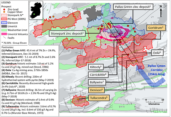
Gortdrum is located within the Company’s 100%-owned PG West project in southwestern Ireland. PG West is situated within the Limerick basin, a geological feature which also hosts the Company’s contiguous 76.56%-owned Stonepark project and Glencore’s adjacent Pallas Green project (hosting the Pallas Green zinc-lead deposit1; see Exhibit 6). Gortdrum was Ireland’s only modern, commercial-scale, copper mine. Copper mineralization has a close spatial association with high-level basic intrusions (similar to Pallas Green, and the Company’s Stonepark and Carrickittle prospects).
The Gortdrum historical estimate2 was discovered in 1966 and was mined (via open pit) from late-1967 to mid-1975 (7.5 years), producing 38 thousand tonnes of copper and 2.9 million ounces of silver. Approximately 500,000 tonnes of high-grade copper remain un-mined on the east-end of open pit (at approx. 100 metres depth). Exploration drilling ceased in 1975 and the prospect lay dormant for over four decades as a prospecting licence was not reinstated over the mine site after mining lease (SML89) expired in 1986. This oversight was identified by Group Eleven in 2014 and the Gortdrum prospecting licenses were awarded in February 2015. In addition to Gortdrum, Group Eleven also owns the only other known advanced copper-silver prospects in Ireland: Denison and Tullacondra (see Exhibit 6).
Exhibit 6. Regional Map of Limerick Region, Showing Copper-Silver Prospects, PG West Project
Notes to Exhibit 1: (a) Pallas Green MRE is owned by Glencore and is reported in accordance with JORC Code on Mineral Resources and Reserves; (b) the historic estimate at Denison was reported by Westland Exploration Limited in 1988, the historic estimate at Tullacondra was reported by Munster Base Metals Ltd in 1973 and the historic estimate at Gortdrum was reported by G.M. Steed in 1986; these three historic estimates have not been verified as current mineral resources; none of the key assumptions, parameters and methods used to prepare the historic estimates were reported and no resource categories were used; significant data compilation, re-drilling and data verification may be required by a Qualified Person before the historic estimates can be verified and upgraded to be compliant with current NI 43-101 standards; a Qualified Person has not done sufficient work to classify them as a current mineral resource and the Company is not treating the historic estimates as current mineral resources.
Qualified Person
Technical information in this news release has been approved by David Furlong, P.Geo., Chief Operating Officer, and ‘Qualified Person’ as defined under Canadian National Instrument 43-101.
About Group Eleven Resources
Group Eleven Resources Corp. (TSX.V: ZNG; OTC: GRLVF and FRA: 3GE) is a mineral exploration company focused on advanced stage zinc exploration in Ireland. Additional information about the Company is available at www.groupelevenresources.com.
ON BEHALF OF THE BOARD OF DIRECTORS
Bart Jaworski, P.Geo.
Chief Executive Officer
E: b.jaworski@groupelevenresources.com | T: +353-85-833-2463
E: s.heinrichs@groupelevenresources.com | T: +604-630-8839
Neither TSX Venture Exchange nor its Regulation Services Provider (as that term is defined in the policies of the TSX Venture Exchange) accepts responsibility for the adequacy or accuracy of this release.
Cautionary Note Regarding Forward-Looking Information
This press release contains forward-looking statements within the meaning of applicable securities legislation. Such statements include, without limitation, statements regarding the future results of operations, performance and achievements of the Company, including the timing, content, cost and results of proposed work programs, the discovery and delineation of mineral deposits/resources/ reserves and geological interpretations. Although the Company believes that such statements are reasonable, it can give no assurance that such expectations will prove to be correct. Forward-looking statements are typically identified by words such as: believe, expect, anticipate, intend, estimate, postulate and similar expressions, or are those, which, by their nature, refer to future events. The Company cautions investors that any forward-looking statements by the Company are not guarantees of future results or performance, and that actual results may differ materially from those in forward looking statements as a result of various factors, including, but not limited to, variations in the nature, quality and quantity of any mineral deposits that may be located. All of the Company's public disclosure filings may be accessed via www.sedar.com and readers are urged to review these materials, including the technical reports filed with respect to the Company's mineral properties.
1 Resources and Reserves Report (Glencore, December 31, 2020) – 45.4 million tonnes of 7% Zn + 1% Pb (Inferred)
2 Gortdrum historical estimate totals 3.8 million tonnes of 1.2% copper and 25 g/t silver as reported by G.M. Steed in 1986. This mineralization was mined out from 1967 to 1975. This historic estimate has not been verified as current mineral resources; none of the key assumptions, parameters and methods used to prepare the historic estimates were reported and no resource categories were used; significant data compilation and data verification may be required by a Qualified Person before the historic estimates can be verified and upgraded to be compliant with current NI 43-101 standards; a Qualified Person has not done sufficient work to classify them as a current mineral resource and the Company is not treating the historic estimates as current mineral resources.


